Amazon Location Service
Overview
Amazon Location Service lets you add location data and functionality to applications, which includes capabilities such as maps, points of interest, geocoding, routing, geofences, and tracking. Amazon Location provides location-based services (LBS) using high-quality data from global, trusted providers Esri and HERE. With affordable data, tracking, and geofencing capabilities, and built-in metrics for health monitoring, you can build sophisticated location-enabled applications. With Amazon Location, you retain control of your organization’s data. Amazon Location anonymizes all queries sent to data providers by removing customer metadata and account information. Additionally, sensitive tracking and geofencing location information, such as facility, asset, and personnel locations, does not leave your AWS account at all.
What is Amazon Location Service?
You can include information about maps, points of attraction, navigation, geocoding, tracking, and geofences using Amazon Location Service (ALS). You may maintain control over the data belonging to your company with Amazon Location. AWS services like CloudTrail, EventBridge, Identity and Access Management (IAM), CloudWatch, etc. are completely linked with Amazon Location.
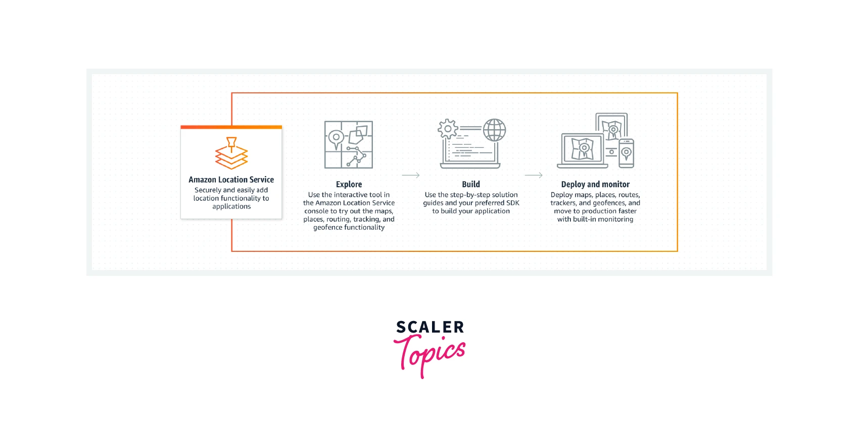
The Explore feature enables you to edit a default map, look for points of interest, practice broadcasting a device's location to trackers, and create geofences around certain locations.
You can generate resources with the Build and select from a choice of map types and data providers. You can then install an SDK that is compatible with your development environment. In addition, by utilizing Amazon CloudWatch and Amazon CloudTrail, you may incorporate monitoring.
Transform Your Career
Choose from our industry-leading programs designed for career success
Modern Software and AI Engineering Program
Master full-stack development with AI integration

Modern Data Science and ML with specialisation in AI
Advanced data science techniques with AI specialization
Advanced AIML with Specialisation in Agentic AI
Deep dive into AIML with focus on Agentic systems
DevOps, Cloud & AI Platform Engineering
Build and manage AI-powered cloud infrastructure
AI Engineering Advanced Certification by IIT-Roorkee
Premier AI engineering certification from IIT-Roorkee
How Does It Work?
With distinct APIs for each resource, Amazon Location Service makes a variety of resources available for requests. Map, Place Index, Routes, Geofence Collection, and Tracker are the resources. Simply construct the resources your application needs in your AWS account, then make location queries using the resources' APIs.
Amazon Location Service Resources
- With consistent APIs, the map resource allows you to use maps from your chosen data source in your applications. Simply add a Place Index resource and enable geocoding/reverse geocoding to your applications to add a geographic search engine.
- Additionally, using the Geofence Collection resource, you may draw lines on your maps and design custom events that will be triggered in response to these geofences.
- You can send location updates, save current locations from devices, and access location data using the accompanying API by using the Tracker resource.
- You can utilize Tracker resources in conjunction with Geofencing to gather and analyze location data by the geofences you've chosen.
- Last but not least, users will be able to request directions, travel times, and distance data using the future Routes resource.
Features of Amazon Location
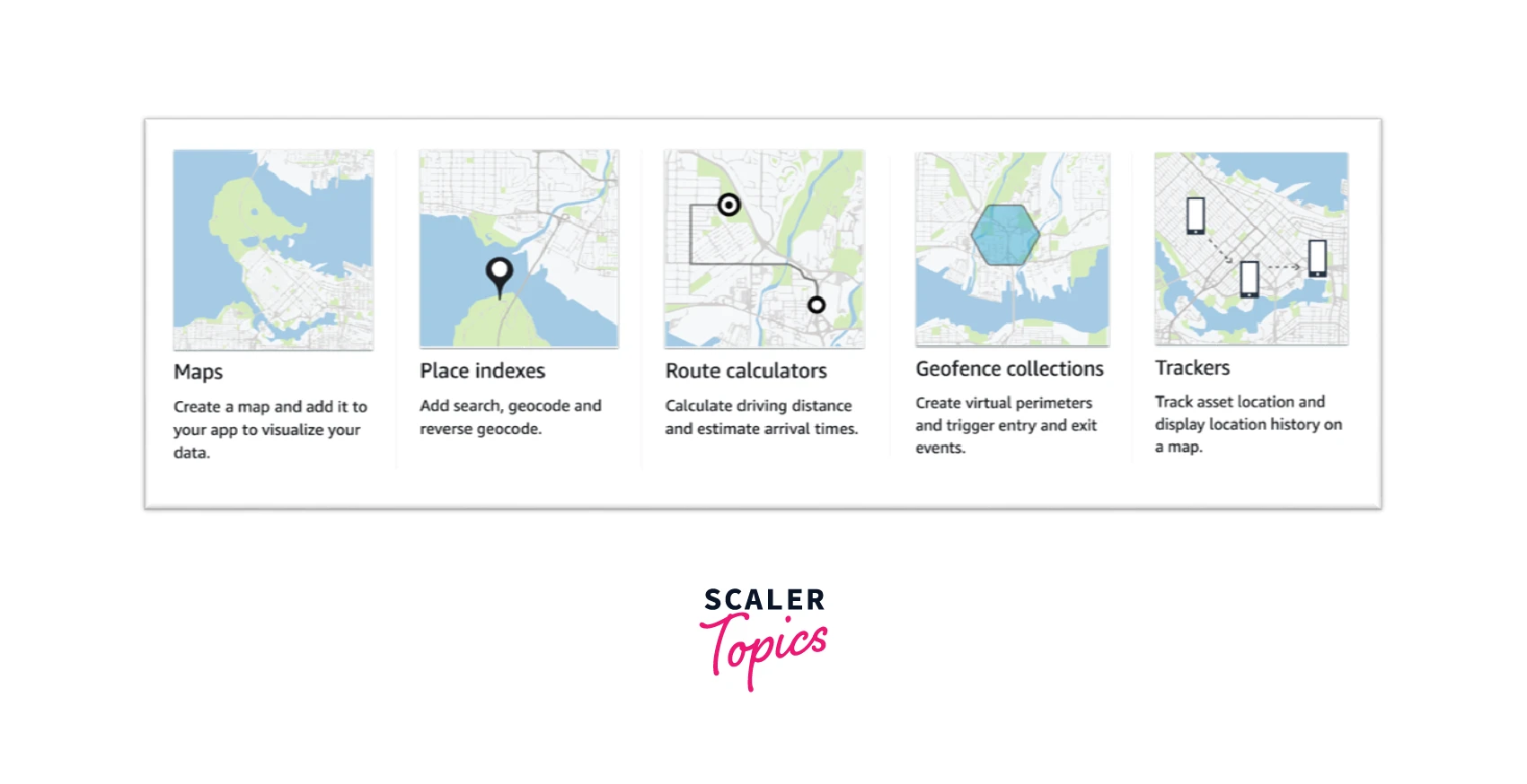
- Maps: You may visualize location data using this Maps Service, which also serves as the basis for many LBS functionalities. Map tiles in a variety of designs will be made available by Amazon Location and obtained from worldwide location data suppliers Esri and HERE.
- Places: You can incorporate search capabilities into your application using Places. Addresses can be made into street addresses by converting them into geographic coordinates. Reverse geocoding is the term for this service.
- Routing: Based on the most recent traffic and road information, you may use this tool to locate the routes and calculate journey times. For a grid of routes, it employs route planning to determine the time and distance.
- Geofencing: With the help of this functionality, your application will be able to recognize whenever a device enters or leaves a geofence—a predetermined geographic boundary—and take appropriate action. An entry or leave event is immediately sent to Amazon EventBridge if a geofence breach is discovered. This can assist you in notifying your target.
- Trackers: You can use this feature to get information about the history and present location of the devices using this service. By filtering location updates that haven't moved before storing or comparing them to geofences, trackers can help you save money. The security aspects of your location will also be handled by these trackers.
Why Amazon Location Service?
- The most well-known LBS provider is Google Maps, therefore Amazon's new service is similar to other LBS providers in that regard. However, it competes with them on price, user-centric privacy policies, and ease of integration for business users.
- According to Amazon, the cost of its location service can be as little as one-tenth of that of the most popular LBS suppliers, and customers only pay for the users, assets tracked, or devices they manage.
- Today, location-based service customers place a high value on privacy. As a result, Amazon's new service ensures user data privacy and security by giving consumers control over which third parties have access to their private information and eliminating account information and customer metadata from inquiries before they are transmitted to an LBS provider.
- Additionally, unless a client chooses to share it, sensitive information tracking and geofencing information never leave the customer's AWS account.
- Finally, the licensing conditions for the Amazon Location Service do not provide Amazon or other parties the right to market or utilize a customer's location data.
- Another USP of Amazon Location Service is that it integrates location-based features from reputable LBS suppliers HERE and Esri into their apps, removing the burden of adding location capabilities to an application.


Amazon Location Use Cases
Asset Tracking
Create asset-tracking capabilities to aid organizations in tracking down the present and past whereabouts of their assets, including workers, infrastructure, and goods. Using the asset tracking tools, you can also create a variety of solutions that enhance dispatch efficiency, protect shipments in transit, and optimize the remote workforce.
Architecture
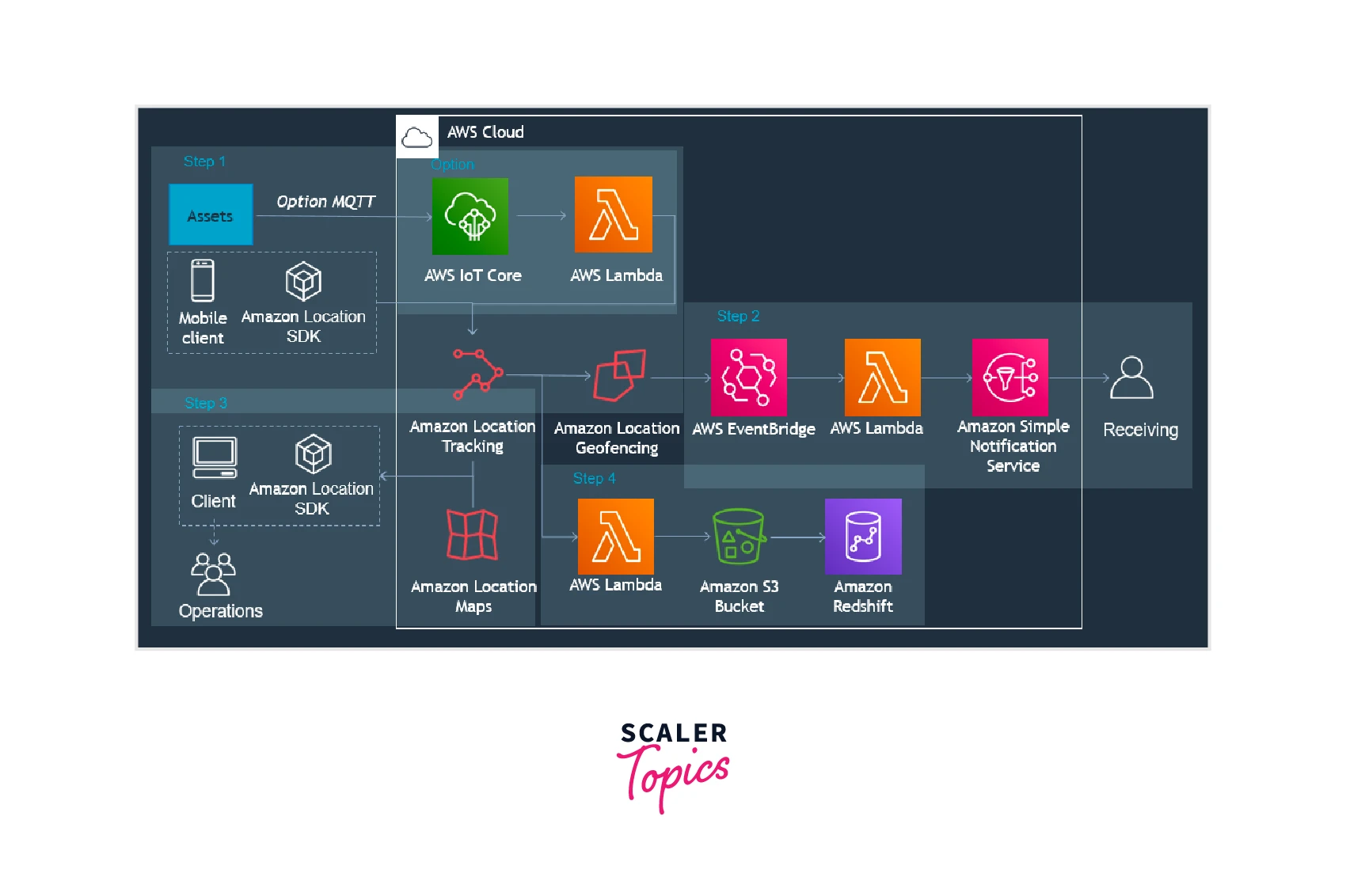
You can use this architecture to show asset locations, start events, show retail customer device locations on a map, analyze location history, and more.
Steps to Creating an Asset Tracking Application:
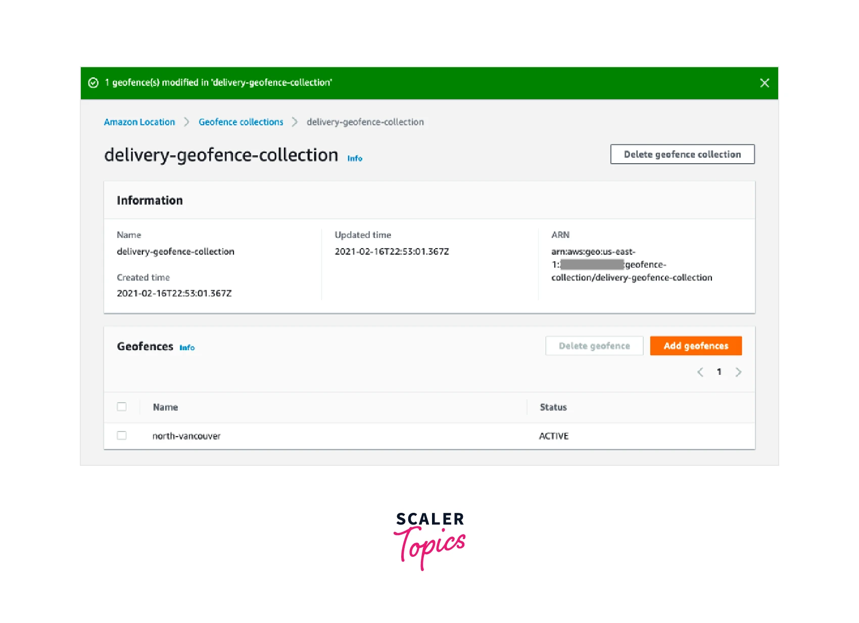
- Assign Trackers to your geofence collections after creating them.
- You can set up Amazon EventBridge to start a procedure or to notify customers.
- Map out your active geofences and your tracked assets. Likewise, store location information for a long time.
- After your application has been created, you can manage it using AWS CloudTrail and Amazon CloudWatch.
Scaler Placement Report and Statistics
Scaler learners achieved 2.5x salary growth with average post-Scaler CTC reaching ₹23L.
Geomarketing and User Engagement
Solutions that enhance user engagement and marketing to specific customers can be created. You may also be permitted to develop geotargeting tools, allowing merchants to deliver digital fliers or discount vouchers to clients who are close to target stores.
Architecture
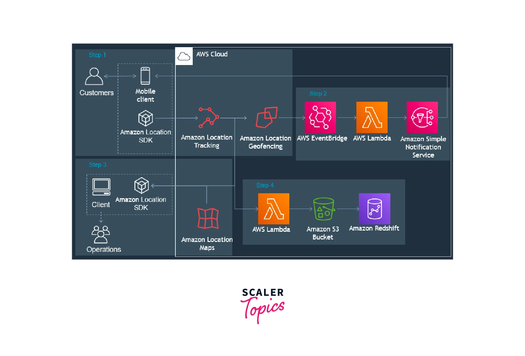
You can use this architecture to start events, view customer device locations, save customer device positions on a map, examine location history, and more.
Steps to Creating a User Engagement and Geomarketing Application:
- Assign Trackers to your geofence collections after creating them.
- You can set up Amazon EventBridge to notify clients when they enter or leave a geofenced area of interest.
- Map out the customer locations and geofences. Likewise, store location information for a long time.
- After your application has been created, you can manage it using AWS CloudTrail and Amazon CloudWatch.
Delivery
Delivery applications that track, store, and manage the starting point, ending point, and delivery vehicles can be created. By doing this, the wait time is cut down and the standard of service is preserved.
Architecture
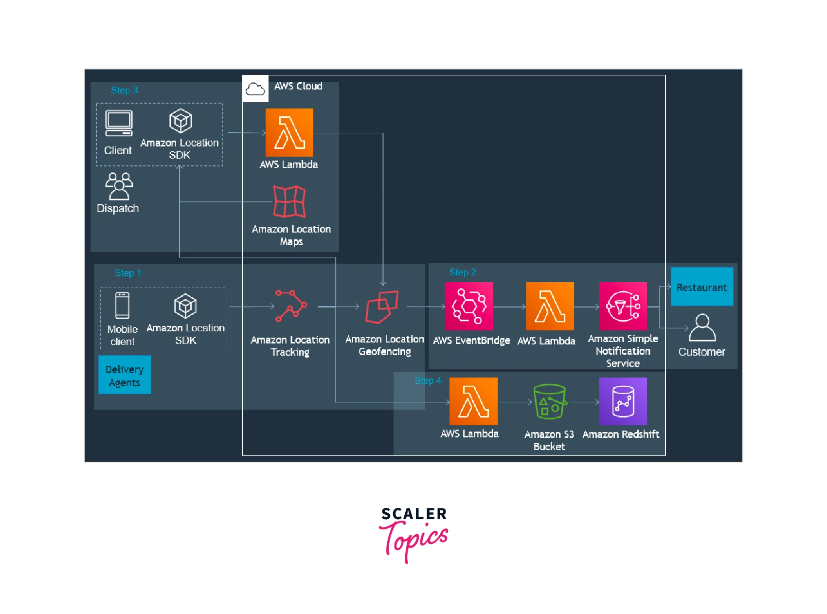
With the aid of this architecture, you will be able to start actions based on the proximity of delivery agents, show driver locations as well as pick-up and drop-off locations, save delivery agent positions on a map, examine location history, etc.
Construction of a Delivery Application:
- Assign Trackers to your geofence collections after creating them.
- To dynamically add and remove geofences when your orders are booked, use an AWS Lambda function.
- Set up Amazon EventBridge to start procedures and send notifications to consumers.
- Show active geofences and tracked objects on a map. Likewise, store location information for a long time.
- After your application has been created, you can manage it using AWS CloudTrail and Amazon CloudWatch.
Amazon Location Service Pricing
There is no minimum price or requirement for an upfront commitment with Amazon Location Service. You only pay for what you use. For the first three months of use, Amazon Location Service is free. Your application will be charged for each request for location data it makes to the service. You must pay for any requests your application makes to the service after the free tier of the Amazon Location Service.
Amazon Location Service Free Tier
For the first three months that you use Amazon Location Service, you can test it out for free. You won't be charged for monthly usage up to the amounts shown in the table below during that time. If your usage goes over the limits of the free tier, you will be charged at the paid tier rates for any additional requests you make.
| Capabilities | Included monthly, for 3 months |
|---|---|
| Maps | 500,000 Map tiles retrieved (Vector or Raster) |
| Places | 10,000 Address suggestion requests. 10,000 Addresses geocoded. 10,000 Positions reverse-geocoded |
| Routes | 10,000 Routes calculated |
| Tracking | 200,000 Positions written. 10,000 Batch position reads. 5,000 Devices deleted |
| Geofencing | 200,000 Positions evaluated. 10,000 Geofences created, deleted, or described. 10,000 Geofence list requests |
| Service Resources | 10,000 Resource create, read, update, delete, or list requests |
To Know More About the Pricing of Amazon Location Service, Please Visit This Link.
Turn Learning into Career Growth
Getting Started with Amazon Location Service
Utilizing the Amazon Location console is the most effective approach to begin using Amazon Location Service.
Developing Amazon Location Resources for Your Application
To Include Location Resources Into Your Application
- Select the type of map you would like to use.
- To preview map styles in the Amazon Location console, go to the Maps page and select Create map.
- For the new map resource, enter a Name and a Description. Keep a record of the name you give to the map resource. Later in the tutorial, when generating your script file, you will require it.
- Select a map.
- Select the place index you want to employ.
- Select Create place index from the Place indexes page in the Amazon Location dashboard.
- For the new place index resource, enter a Name and a Description. Note the name you give the resource for the place index. Later in the tutorial, when generating your script file, you will require it.
- Select a data source.
- Choose the Data storage option. For this tutorial, the results are not stored, so you can choose No, single-use only.
Establishing Authentication for Your App
- Visit the Amazon Cognito interface.
- Select Manage Identity Pools.
- Select Create new identity pool, then give your identity pool a name.
- Select Enable access to unauthenticated identities from the Unauthenticated identities collapsible section.
- Select Create Pool.
- The IAM roles you want to utilize with your identity pool can be chosen.
- View Details by expanding.
- Enter a role name under Unauthenticated identities.
- To add your policy, expand the View Policy Document section and then select Edit.
- To allow access to your resources, add your policy.
Amazon Location Service Customers
Amazon Location Service is being used by customers all over the world to create location-based apps.
- PostNL: It is the top provider of postal logistics and e-commerce in the Netherlands. PostNL connects the real and digital worlds by delivering an average of 8.1 million letters and 1.1 million parcels each weekday throughout Belgium, Holland, and Luxembourg.
- Command Alkon: The heavy construction sector receives technical solutions from Command Alkon. The 45-year-old business is a pioneer in its field and develops cutting-edge software and industrial systems for clients all over the world.
- TCS Business and Technology Services: With its offerings across digital technologies, such as Cloud, IoT, Business Functions, Security, Cryptography, Blockchain, Data, and Analytics, TCS assists businesses in becoming future-ready. TCS blends technological know-how with business insight to spur transformation and produce outcomes.
- MobileLog: A service called MobileLog enables companies to track and trace their goods and cars in real-time. MobileLog enables businesses to track their mobile assets, check deployments on maps, issue orders to drivers, and even receive seamless customer feedback for just €15 per month.
- Novetta: Novetta is a data analysis firm that specializes in sifting through the muddled complexity of big data to reveal the truth at the pace and scope required for the most demanding tasks in national security.
Amazon Location Service Alternatives & Comparisons
- Google Maps: Utilizing the thoroughness, accuracy, and accessibility of Google Maps and a cutting-edge web platform that grows as your business expands, you can create complex applications and spectacular visualizations of your data.
- Mapbox: It enables the sharing of trip photos on Pinterest, the discovery of dining options on Foursquare, and the visualization of data on GitHub.
- Leaflet: A free JavaScript library for creating mobile-friendly interactive maps is called Leaflet. Vladimir Agafonkin of MapBox and a group of devoted developers are working on its development. It provides all of the capabilities that the majority of developers would ever need for online maps and is only about 30 KB of gzipped JS code.
- OpenLayers: A free, open-source Javascript toolkit for loading, showing, and rendering maps on websites.
- OpenStreetMap: A global community of mappers contributes and maintains data about highways, trails, cafes, train stations, and many other things to OpenStreetMap.
Conclusion
- One example of a location service is Amazon Location Services. You can include information about maps, points of interest, navigation, georeferencing, tracking, and geofences using Amazon Location Service (ALS).
- A range of services are offered by Amazon Location. Maps, Places, Routing, Geofences, and Tracking of the developer's applications are among these.
- Very good security is provided by Amazon Location Service. It uses Signature versions and various other checks to verify all the data that is transmitted over the related applications.
- User Engagement and GeoMarketing are the first and most well-known use cases for devices or applications created with Amazon Location Services. Delivery applications rank second and asset tracking comes in third.
- Amazon Location Service will accept location details with a precision of six decimal places. At the equator, that is also equivalent to 11 cm or 4.4 inches.